Detailed Maps Show Estuarine Wetlands and Seagrass Areas
Two new map layers in the Portal’s Marine Life collection offer a tour of the locations of the Mid-Atlantic’s diverse estuarine wetlands and seagrass areas. Taken together, the maps will serve as a valuable resource for coastal planning and management decisions, as well as an educational tool for the public on these critical habitats for numerous species of fish and birds.
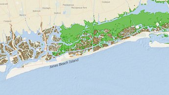
The Estuarine Wetlands map displays U.S. Fish & Wildlife Service National Wetlands Inventory (NWI) data showing the extent of tidal, saltwater wetlands in the region. The map delineates emergent wetlands (marshes) in brown, forested wetlands in green and scrub-shrub wetlands (areas dominated by trees or shrubs that are small or stunted because of environmental conditions) in orange.
The Seagrasses map shows the locations of patchy and continuous seagrasses along the East Coast. Users can click on locations on the map for pop-ups with further information on the types of vegetation, estimated percentage of seagrass coverage in the area and the origin of the data. The map data is provided by the National Oceanic and Atmospheric Administration Office for Coastal Management.
Since these maps are focused on small areas along the
Mid-Atlantic’s coast and estuaries, users should zoom in close to examine each
location in full detail.
Share this story