Map Collection Shows Region’s Vast Network of Coastal Water Trails
Take an online cruise through thousands of miles of coastal water trails in the Mid-Atlantic with a collection of interactive maps in the Portal’s Recreation theme.
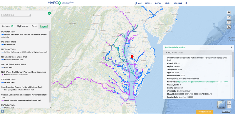
Ten new maps show the routes for publicly designated and accessible water trails in coastal areas of New York, New Jersey, Pennsylvania, Delaware, Maryland and Virginia. Users can browse the maps to plan canoeing, kayaking and boating excursions, and consult the Portal’s thousands of additional data layers to learn about the marine life, maritime activities and other interesting features they’ll encounter along the way. The maps also hold value for ocean and coastal planners as tools to learn about important recreational areas and mitigate potential conflicts with other users of those waters.

Stand-up paddleboarders and canoeists enjoy the Hudson River, part of both the New York City Water Trail and greater Empire State Water Trail system.
Water trails, also known as blueways, are marked routes on waterways such as rivers, canals, lakes and coastlines designed for people using small watercraft. As the maps show, the Mid-Atlantic coast is home to water trail systems that weave through environments ranging from serene wildlife refuges to America’s busiest urban waterfronts.
Users can click on the water trail routes for pop-up windows containing additional information about them, such as the route name, details about access points, and links to websites and brochures dedicated to them. (The types of information available varies from layer to layer, as the data was obtained from separate sources.)
The collection focuses on water trails that begin or end in coastal areas (within 10 kilometers of beaches or the shores of major estuaries) in the five-state Mid-Atlantic Regional Council on the Ocean (MARCO) region. In some cases, data is included for routes that are located beyond that boundary, but connect to coastal water trails and therefore serve as extensions of them. Portal users can consult the links provided in the descriptions below to view the original source data, which may show additional water trails in non-coastal areas. Below is a summary of the 10 water trail maps included in the collection.
Mid-Atlantic State Maps
DELAWARE
DE Water Trails: This map shows a combination of water trails derived from Delaware Natural Resources and Environmental Control GIS data and digitized versions of PaddleCoastalDelaware.com routes from brochures produced by the University of Delaware with several public and private sector partners.
MARYLAND
MD Water Trails: Includes coastal water trails extracted the Maryland Department of Natural Resources Online Water Access Guide web app.
NEW JERSEY
NJ Water Trails: This layer combines GIS data from the New Jersey Department of Environmental Protection’s Statewide Trails web app with digitized versions of routes featured in brochures produced by the New Jersey Sports and Exposition Authority, Camden County Parks Department and Musconetcong Watershed Association.
NEW YORK
NY Empire State Water Trail: A contiguous network of water trails that extends to Lake Erie to the west and Lake Champlain to the north and flows down the Hudson River to Upper New York Bay. Click here to view the Empire State Water Trail website.
NY-NE Portal Water Trails: Produced by the Northeast Ocean Data Portal, this layer includes additional coastal water trails in New York State as well as routes in New England.
NYC Water Trail Human-Powered Boat Launches: Rather than a linear trail route, the New York City Department of Parks and Recreation website presents the NYC Water Trail as a network of launch sites throughout the five boroughs.
VIRGINIA
VA Water Trails: GIS data for water trails presented on the Coastal Virginia Ecotourism Alliance’s virginiawatertrails.org website were provided to the Portal by the Virginia Coastal Zone Management Program at the Department of Environmental Quality.
Additional Data
Captain John Smith Chesapeake National Historic Trail: This water trail network extending approximately 3,000 miles throughout the Chesapeake Bay watershed traces the historic routes mapped during the 1607-09 voyages of Capt. Smith. Data obtained from the National Trails System GIS web map.
Star-Spangled Banner National Historic Trail: This second Congressionally designated water trail in the region traces American and British troop movements during the War of 1812, introduces visitors to communities affected by the war, and highlights the Chesapeake region’s distinctive landscapes and waterways. Data obtained from the National Trails System GIS web map.
PA Water Trails: Four water trails that extend from routes in coastal areas of Mid-Atlantic states were extracted from the Pennsylvania Department of Conservation and Natural Resources Explore Pennsylvania Trails web app.
Future Updates

A boat rental business along the Seaside Water Trail in Virginia.
This collection will be updated periodically to account for newly designated water trails or additional data that becomes available. If you’re aware of other Mid-Atlantic coastal water trails or datasets that should be considered for inclusion, please contact us at portal@midatlanticocean.org.
The MARCO Portal team extends its thanks to the many state, federal and local agencies and organizations that provided source data and assistance in assembling this collection.
Share this story