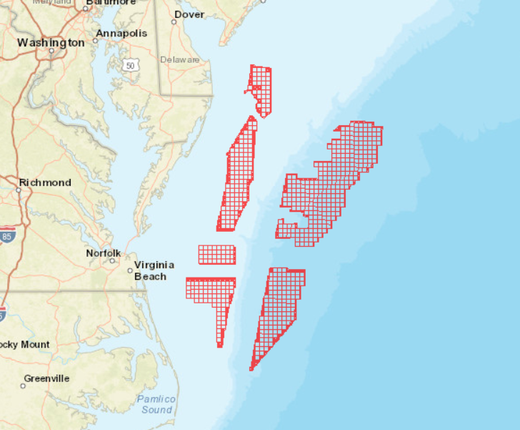
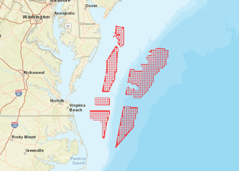
The Bureau of Ocean Energy Management (BOEM) has published a Call for Information and Nominations to assess commercial interest in and obtain public input on potential wind energy leasing activities in federal waters of the Central Atlantic. An interactive map showing the boundaries of the Call Area, which spans from Delaware to North Carolina, can now be viewed on the Portal.
The BOEM Central Atlantic Call for Information and Nominations Area map layer can be found by clicking on the “Planning and Lease Areas” dropdown in the Portal’s Renewable Energy theme. Users can analyze the Call Area in combination with any of the Portal’s thousands of other map layers and submit their comments to BOEM by June 28, 2022. A Federal Register notice published April 29 contains instructions for submitting comments and other information about the Call Area.
The Call Area can also be viewed in the BOEM Wind Planning Areas map layer along with areas under consideration for wind power development in the New York Bight, Gulf of Mexico, West Coast waters, and off the coast of the Carolinas.
The Call Area contains six zones (designated areas A-F) that cover approximately 3.9 million acres:
- Call Area A begins approximately 20 nautical miles offshore of Delaware and Maryland and comprising approximately 235,222 acres. It includes a gap toward its center where an artificial reef is located.
- Call Area B begins approximately 21 nautical miles offshore of Maryland and Virginia and comprises approximately 652,218 acres.
- Call Area C begins approximately 35 nautical miles offshore of Virginia and comprises approximately 183,907 acres.
- Call Area D begins approximately 24 nautical miles offshore of Virginia and North Carolina and comprises approximately 442,553 acres.
- Call Area E begins approximately 56 nautical miles offshore of Delaware, Maryland, and Virginia (beyond the continental shelf break) and comprises approximately 1.6 million acres.
- Call Area F begins approximately 44 nautical miles offshore of Virginia and North Carolina (beyond the continental shelf break) and comprises approximately 763,491 acres.
The map delineates 496 whole outer continental shelf (OCS) lease blocks and 298 partial blocks that form the six areas. Users can click any point within the Call Area for a popup containing the area name, lease block number, Federal Register notice link, and a link to a BOEM web page containing more information about wind planning activities in the Central Atlantic.
More Offshore Wind Data on the Portal
The Portal’s Renewable Energy theme contains several other maps depicting offshore wind power development activities and infrastructure throughout the East Coast. In addition to the Planning and Lease Areas, there are three dropdowns (Offshore Energy Projects Under Review, Permitted Projects, and Operational Offshore Energy Projects) that organize project data by their stage of development. The theme also includes maps showing energy facilities, electric transmission lines and substations along the coast.
Users can also find a series of maps created by the National Renewable Energy Laboratory showing average monthly and annual wind speeds along the coast in the Oceanography theme.
Questions or comments? Email us at portal@midatlanticocean.org.