Learn how to use the Portal's tools
This page offers a list of instructional materials and resources for users interested in learning more about our tools and data. Users can also visit our Data Catalog for explanations about any specific map layer.
The Portal is continually under development with new data and features to meet our users’ needs. We encourage users to visit the Portal News blog regularly for details about the latest site updates and see our Calendar page for upcoming sessions of our How Tuesday instructional webinar series.
General: The Portal & its Tools
- Portal
overview video (3 mins.) & fact sheet
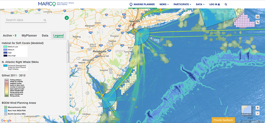
- Marine Planner Basics: Video tutorial | Diagram (PDF)
- How to use the Drawing Tool
- How to use the Linear Measurement Tool
- How to use the Marine Life Library search tool
- How to use the Communities at Sea search tool (video)
- How to use the Marine Planner ArcRest services input tool
- How to use and create Portal Groups (video)
- How to use the Slider & Animation tool | Video tutorial
- Full “Portal 101” overview lesson from our March 2017 How Tuesday webinar
- Tour some of our most popular data collections with this Mid-Atlantic Ocean Data Portal Story Map
- Portal Self-Paced Walk Through document (PDF)

Select Data Guides by Topic (alphabetical order)
Acidification monitoring data overview
Artificial Reefs data overview
Department of Defense/Security data overview
Fishing data
- Overview of commercial fishing VTR, VMS and Communities at Sea maps
- Video demonstration of Communities at Sea search tool
- June 2018 webinar on Portal fishing data
Human Use Data Synthesis (HUDS) project & maps overview – May 2016 webinar
Marine Life data:
- Marine life data on the Portal/Marine Life & Data Analysis Team (MDAT) project: Text overview | September 2018 webinar
- Guide to searching for individual species in Marine Life Library: Text overview | Video tutorial
- Fish Species Shifts: Past decades and future projections
- Diving bird migration patterns
- Loggerhead Sea Turtle monthly slider
- Bathymetry and Seabeds data description
- Overview of Fronts Probability and Net Primary Productivity data
- MARACOOS seasonal surface currents and monthly surface temperature overviews | Webinar
Offshore wind
- BOEM New York Bight Call Areas description
- New York State Identified Wind Energy Area of Consideration description
Recreation
- Summary of state-by-state map data
- Recreational boater survey data overview in Ocean Stories
- Non-consumptive recreation survey data overview in Ocean Stories
Regional Ocean Assessment (ROA) overview – March 2016 webinar
Socioeconomic
- MARCO county-level seasonal housing and ocean employment data
Submarine cables overview
