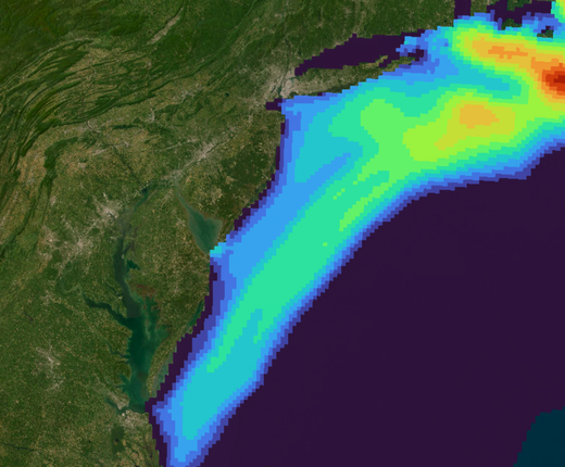
To visualize and characterize shifts in North Atlantic right whale distribution, the Marine-life Data & Analysis Team (MDAT) has developed a new dataset that has been added to the marine life libraries on the Mid-Atlantic Ocean Data Portal and Northeast Ocean Data Portal. The critically endangered North Atlantic right whale is the subject of numerous visual and acoustic surveys throughout its range, which have allowed for the identification of a shift in distribution that occurred around 2010 (Davies et al. 2019, Davis et al. 2017). This shift in right whale distribution has been linked to changes of their prey abundance, Calanus spp., throughout their range (Meyer-Gutbrod et al. 2023).
The new map contains three modeled datasets developed by the Duke University Marine Geospatial Ecology Lab (MGEL), each modeled by month: North Atlantic right whale density for two time periods, 2003-2009 and 2010-2019, and a difference layer showing 2010-2019 minus 2003-2009. The difference layer is visualized with a log scale to best show where North Atlantic right whale density has increased or decreased between the two time periods.
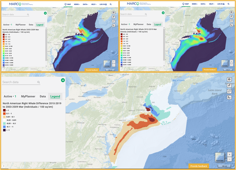
The maps above show right whale density in March 2003-2009 (top left), right whale density in March 2010-2019 (top right) and the difference in density between these two time periods (bottom). In the bottom map, red tones represent areas where right whale density increased between the two time periods, and blue tones represent a decrease in density between the two time periods. White represents no or very little change.
Mid-Atlantic Ocean Data Portal users can find the North Atlantic Right Whale Change Over Time Sliders in the Marine Life theme.
The MARCO Portal has also added a Right Whale Dynamic Management Areas (Slow Zones) map showing areas where NOAA Fisheries advises mariners to hold their speeds to 10 knots or less to help protect right whales. DMAs are updated hourly and based on visual sightings documenting the presence of three or more right whales within a discrete area. Users can click a DMA for a popup containing the boundaries of the area and its expiration date. The layer can be found in the Portal’s Maritime theme.
For portal users who have previously accessed the North Atlantic right whale density models from MDAT, the most recent density layers (2010-2019 density) in this dataset are the same modeled density included in the individual species models provided by MDAT. The model resolution for both the density models and the difference layer are 5km x 5km. The 2010-2019 right whale density model included in this dataset and under the individual species models remains the recommended density surface for management decisions.
The model results were compared to published literature to confirm that the shifts in north Atlantic whale distribution identified by the models accurately reflected changes in distribution and were not due to changes in underlying model parameters. The detailed comparisons for different regions along the US east coast are available in Roberts et al. 2024, as well as further information on the model methods.
COMING SOON: Both Portals will soon add layers depicting North Atlantic right whale zooplankton prey species, known as Calanus spp., that are hypothesized to explain the changes in right whale distribution shown in the new maps above. Portal users will be able to overlay and examine Calanus abundance as recorded by the NOAA Northeast Fisheries Science Center’s Ecosystem Monitoring (EcoMon) Program using new layers that are aligned with the same time periods (2003-2009, 2010-2019) and monthly intervals as the right whale layers.
Citations and Additional Information
- Roberts JJ, Yack TM, Fujioka E, Halpin PN and others (2024) North Atlantic right whale density surface model for the US Atlantic evaluated with passive acoustic monitoring. Mar Ecol Prog Ser 732:167-192. https://doi.org/10.3354/meps14547
- Roberts JJ, Yack TM, Halpin PN (2023) Marine mammal density models for the U.S. Navy Atlantic Fleet Training and Testing (AFTT) study area for the Phase IV Navy Marine Species Density Database (NMSDD). Document version 1.3. Report prepared for Naval Facilities Engineering Systems Command, Atlantic by the Duke University Marine Geospatial Ecology Lab, Durham, North Carolina.
- Davies KTA, Brown MW, Hamilton PK, Knowlton AR, Taggart CT, Vanderlaan ASM (2019) Variation in North Atlantic right whale Eubalaena glacialis occurrence in the Bay of Fundy, Canada, over three decades. Endang Species Res 39:159-171. https://doi.org/10.3354/esr00951
- Davis, GE, Baumgartner, MF, Bonnell, JM et al. (2017) Long-term passive acoustic recordings track the changing distribution of North Atlantic right whales (Eubalaena glacialis) from 2004 to 2014. Sci Rep 7, 13460. https://doi.org/10.1038/s41598-017-13359-3
- Meyer-Gutbrod, EL, Davies, KTA, Johnson, CL, Plourde, S, Sorochan, KA, Kenney, RD, Ramp, C, Gosselin, J-F, Lawson, JW and Greene, CH. (2023) Redefining North Atlantic right whale habitat-use patterns under climate change. Limnol Oceanogr, 68: S71-S86. https://doi.org/10.1002/lno.12242