Five new maps showing the proposed locations for offshore wind energy infrastructure such as turbines, transmission cables, and substations throughout the region can now be viewed on the Portal. The map layers present the most up-to-date publicly available plans submitted by developers to the Bureau of Ocean Energy Management (BOEM).
Since proposed project design, review, and permitting is an ongoing process, the final design and buildout of the features may be significantly different than what is shown in the map layers. For some projects, more than one proposed layout (e.g. preferred or alternative) is provided. The Portal will continue to update the maps as new public information becomes available. Newer proposals may have been submitted to BOEM's Office of Renewable Energy Programs which have yet to be reviewed and made public.
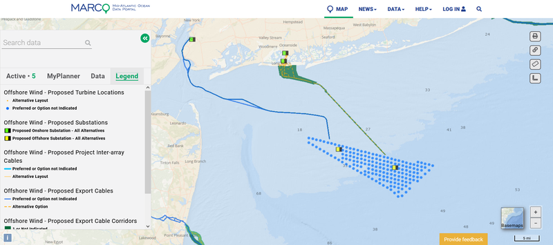
The maps can be accessed in the Renewable Energy theme by clicking on the “Offshore Energy Projects Under Review” dropdown. (Click here to view them all.) They include:
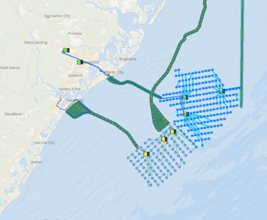
Offshore Wind - Proposed Export Cable Locations: This map shows the routes of cables that developers intend to build to transmit electricity to shore. Users can click the cables for popup windows containing data such as the route name, cable length and proposed burial depth range.
Offshore Wind - Proposed Project Inter-array Cables: The lines shown in this layer represent the proposed cable linkages between turbines or between turbines and offshore substations within a wind project.
Offshore Wind - Proposed Substations: This layer shows the proposed sites of offshore substations that would be fed power from the wind turbines via cables and act as collectors to transport the electricity to the export cable, or out to consumers via onshore substations. When available, the locations of proposed onshore substations associated with projects are also shown.
Offshore Wind - Proposed Turbine Locations: Users can view the proposed locations of wind turbines within project envelopes and click on the points for popups containing additional information such as anticipated turbine heights, model information and power outputs.
Offshore Wind - Proposed Export Cable Corridors: These polygons represent the potential area (easement) in which proposed locations of the export cable portions of a wind farm may be and are meant to show the area that the developer intends to investigate for the final location of one or more export cables. Users can click the corridors for information including their maximum anticipated cable count and project name.
The Mid-Atlantic Regional Council on the Ocean (MARCO) produced the maps of the proposed export cables, inter-array cables, substations and turbine locations using data provided by BOEM. The original BOEM map layers depicted installed offshore wind infrastructure in addition to the proposals. The metadata links and Data Catalog entries for these layers direct users to the original BOEM data.
The Portal’s Renewable Energy theme contains a wealth of additional data depicting offshore wind projects at various stages of development. The “Planning and Lease Areas” dropdown contains maps showing BOEM active renewable energy lease areas and wind development planning areas off the Atlantic Coast, and periodically includes proposals that federal and state agencies are seeking public comment on. In addition to the five new layers, the “Offshore Energy Projects Under Review” collection includes the envelopes for several projects that are currently being evaluated; the “Permitted Projects” collection includes projects that are preparing for or are under construction; and the “Operational Offshore Energy Projects” dropdown includes maps of existing infrastructure off the coasts of Virginia Beach, Virginia, and Block Island, Rhode Island. Also provided in the theme are maps showing the locations of existing coastal energy facilities and onshore transmission lines and substations.
The Proposed Export Cable Locations and Inter-Array Cables layers have also been added to the “Submarine Cables and Pipelines” collection in the Maritime theme.
Questions? Contact us at portal@midatlanticocean.org.