We’re pleased to announce the following recent improvements and data additions to the Mid-Atlantic Ocean Data Portal.

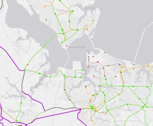
Electric Transmission Lines: Voltage: This map layer shows the routes of above-ground, underground and submarine power lines throughout the Mid-Atlantic and Northeast regions. Line voltages are represented by varying colors and widths. Users can click on a line for a pop-up containing additional information. The map can be found within Marine Planner’s Renewable Energy theme.
Electric Substations: Max Voltage: This map layer shows the locations of electric substations with voltages of 69 kilovolts or higher throughout the Mid-Atlantic and Northeast. Voltage levels are represented by varying colors, and larger squares indicate facilities with higher capacities. Users can click on sites for pop-ups containing additional information about individual substations. The map can be found within Marine Planner’s Renewable Energy theme.
Gray Basemap: In response to user requests, we’ve added a grey basemap to the menu of options available in Marine Planner. The basemap can be useful for highlighting contrasts with colored data layers, as well as for improving the experience for users with vision impairments.
Bookmarks Tool
Upgrade: Users can now bookmark maps with layers that are generated by the
search widgets found in the Marine
Life Library (Species Specific) and Fishing
– Communities at Sea (by Ports) themes. The tool can also now save maps containing
external data layers that are ingested through the ArcRest
Services Input Tool. Bookmarks can only be created by registered users.