
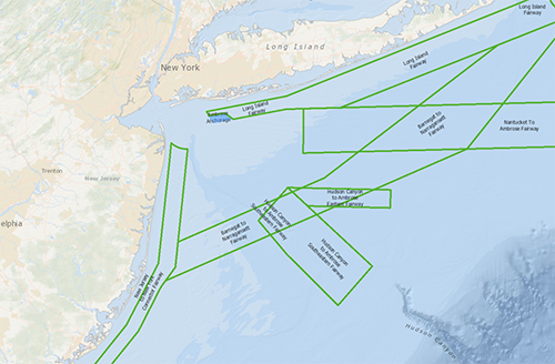
The First Coast Guard District has completed a Northern New York Bight Port Access Route Study (NNYBPARS) to evaluate the adequacy of existing vessel routing measures and determine whether additional ones are necessary for port approaches to New York and New Jersey and international and domestic transit areas in the district's area of responsibility. A new map on the Portal displays a network of shipping safety fairways leading to and from the port area and an anchorage area off the coast of Long Island that were proposed in the final report.
The NNYBPARS final report is available for viewing and download on the Federal Register docket and the Coast Guard Navigation Center website.
In 2019, the Coast Guard initiated a series of port access route studies (PARS) focused on major ports along the Atlantic Coast. These new studies supplement and build on the Atlantic Coast Port Access Route Study (ACPARS) completed in 2017. The studies have gathered a wide range of data and stakeholder input on future maritime commerce trends, Coast Guard missions, potential conflicts with offshore wind projects, port infrastructure changes and many other factors to evaluate the adequacy of existing routing measures and determine whether additional ones are necessary to safely accommodate vessel traffic. The reports recommend new shipping lanes designed to connect the ports to a broader network of fairways proposed by the ACPARS that extend from New England to Florida.
The new Port Access Route Study Final Recommendations: Northern New York Bight map layer has been added to the USCG Proposed Areas and Studies dropdown in the Portal’s Maritime theme. In the same section, users can also find the Port Access Route Studies (PARS) Areas map layer showing the NNYBPARS study area (and three others in the Mid-Atlantic) as well as a ACPARS ANPRM layer showing potential fairways proposed by the ACPARS.
Users can click any of these areas on the map for pop-ups containing links to their Federal Register notices and documentation. It is recommended that Portal users also activate the Routing Measures map layer in the Maritime theme or use the Nautical Charts basemap to view connections between the PARS proposals and existing traffic lanes, fairways, separation zones and precautionary areas.
Questions about using the Portal or its data may be directed to portal@midatlanticocean.org.