*This post has been updated to reflect the extension of the public comment period to Sept. 30.
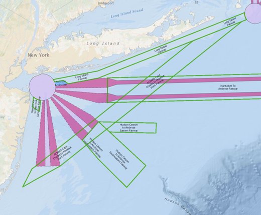
The U.S. Coast Guard has published a Northern New York Bight Port Access Route Study (NNYBPARS) draft report that recommends a series of routing measures designed to accommodate vessels heading to and from the New York Harbor area and around proposed offshore wind energy areas off the coasts of New Jersey and New York.
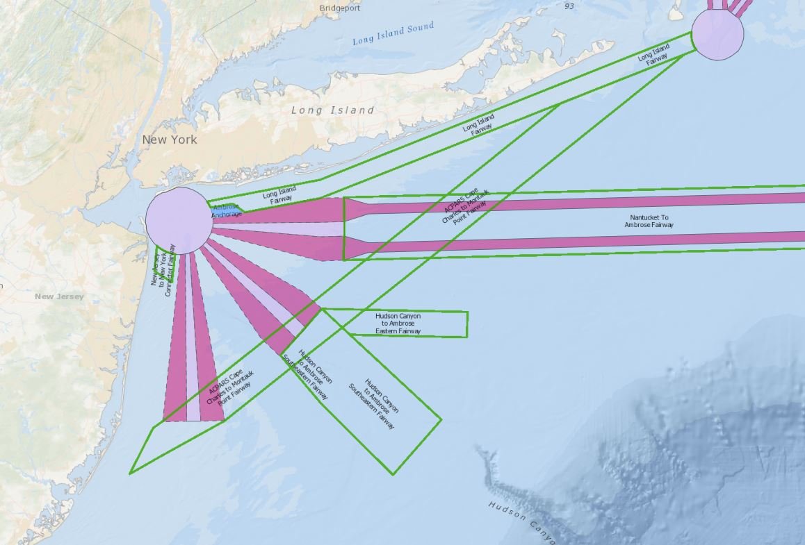
In 2019, the Coast Guard initiated a series of port access route studies (PARS) focused on major ports along the Atlantic Coast. These new studies supplement and build on the Atlantic Coast Port Access Route Study (ACPARS) completed in 2017. The studies are gathering a wide range of data and stakeholder input on future maritime commerce trends, Coast Guard missions, potential conflicts with offshore wind projects, port infrastructure changes and many other factors to evaluate the adequacy of existing routing measures and determine whether additional ones are necessary to safely accommodate vessel traffic. The reports recommend new shipping lanes designed to connect the ports to a broader network of fairways proposed by the ACPARS that extend from New England to Florida.
A new Port Access Route Study: Northern New York Bight map layer showing these proposed lanes has been added to the USCG Proposed Areas and Studies dropdown in the Portal’s Maritime theme. In the same section, users can also find the Port Access Route Studies (PARS) Areas map layer showing the NNYBPARS study area (and three others in the Mid-Atlantic) as well as a ACPARS ANPRM layer showing potential fairways proposed by the ACPARS. Users can click any of these areas on the map for pop-ups containing links to their Federal Register notices and documentation. Portal users may also activate the Routing Measures map layer in the Maritime theme or use the Nautical Charts basemap to view connections between the PARS proposals and existing traffic lanes, fairways, separation zones and precautionary areas.
The draft NNYBPARS report, supporting documents and instructions for submitting comment can be found on the Federal Register. The public comment period for the report will close on Sept. 30, 2021.
Questions about using the Portal or its data may be directed to portal@midatlanticocean.org.
Watch PARS Webinar
Learn more about the NNYBPARS draft report and other PARS under way in the Portal’s Sept. 14 “How Tuesday” webinar below. On the webinar, representatives of the Coast Guard provided updates on the PARS and answered participants’ questions in an open Q&A session. The webinar featured demonstrations on how to access and use the Coast Guard maps on the Mid-Atlantic and Northeast ocean data portals and a Coast Guard Navigation Center GIS Web App.
Presenters included John Stone, Office of Navigation at Coast Guard Headquarters in Washington, D.C.; Capt. Maureen Kallgren, U.S. Coast Guard District 5, Portsmouth, Virginia; Lt. Cdr. Michael Wysong, U.S. Coast Guard District 1, Boston; Lt. Cdr. Ian Hanna, U.S. Coast Guard Navigation Center, Virginia; Karl Vilacoba, Monmouth University Urban Coast Institute/MARCO Portal team; and Emily Shumchenia, Northeast Regional Ocean Council.